

Kenya sets up own geo-hazard surveillance system to monitor distribution, strength of seismic events
Kenya is developing a modern geo-hazard monitoring system for tracking potentially destructive seismological activities to shield the country against grave threats posed by subterranean perils.
The surveillance system will see Kenya join the league of nations that own and operate a homegrown geohazard monitoring national network to map, collect, collate and analyse data relating to origins, patterns, distribution and strength of seismic events including earth quakes, tsunamis, tremors, volcanic eruptions and landslides.
This system is part of strategic vision by the state department of mining to install a formidable infrastructure to act as an early warning system, in addition to bolstering the country’s effort in establishment of seismic data-gathering stations for multiple geo-hazards.
The Principal Secretary in the State Department for Mining Elijah Mwangi says the department is keen on building an advanced system for geo-hazards surveillance to strengthen Kenya’s capabilities for combating emerging and existing dangers from natural calamities from the earth crust.
The needs for disaster preparedness is informed by volcanic eruptions in 2005 that led to the theory of Africa’s split following cracks in the country’ section of the Rift Valley.
The split theory says the African continent, situated on the African Plate, is experiencing significant geological changes due to the movements of the surrounding tectonic plates.
Most notable of these changes, according to the theory, is the ongoing formation of the East African Rift System due to the slowly separating Nubian and Somali tectonic plates. This rifting process has been taking place for millions of years.
It is gradually widening the Rift Valley, potentially splitting Africa into two separate landmasses and leaving space for a brand new ocean – free of charge.
The system, he notes, will be critical in provision of accurate data required in making informed decisions and responses relating to geo-hazards.
“The monitoring the occurrence of events like volcanic eruptions, quakes, tremors, landslides and sinkholes is key to safeguarding national development including people and property. This is what the system is poised to do,” he says.
Kenya’s preparedness to handle major disasters like earthquakes has often been treated as a brief footnote in most geological discourses. However, factors like the burgeoning population, rapid urbanization and accelerated growth of cities and towns have given prominence to conversations on safety over the many geological hazards the country is prone to.
Kenya falls within the Great Rift Valley; a vast geological zone stretching from Afar region of Eritrea to Mozambique, an area geological experts consider seismically active.
The country has in the recent past experienced incidents of earth tremors. The latest incident was in July last year with the Earthquake Monitor reporting a magnitude of 4.6. Local geophysicists agree the country is vulnerable to severe geo-hazards and thus the call to create mechanisms to counter such risks.
The most severe earthquake ever recorded in Kenya was in 1928 at Subukia with a recorded seismic strength of a 6.8. Luckily, the quake had minimal damage owing to little development and sparse population in the area.
Head of Geophysics Unit at Mining Department John Ogalo, says a local seismic surveillance network will bolster efforts in monitoring and gathering data on types and patterns of multiple geo-hazards within the country.
“Our local network will give us advantage in terms of timely access and real-time receiving, processing and analysing of firsthand data on any seismic activities within the country,” he said.
Currently, Kenya hosts a number of foreign-based stations that first report any recorded seismic activity to their mother countries. They include Comprehensive Nuclear Test-Ban Treaty Organization (CTBTO) in Vienna and United States Geological Survey (USGS) in USA. Other bodies like Kenya Electricity Generating Company (KenGen) and Geothermal Development Corporation (GDC) have their mini-networks for exclusive monitoring of activities within their geothermal wells.
However, effective monitoring of seismic activities for Kenya entails the establishment of a triangulated system with strategically positioned stations for real-time data gathering and transmission.
Already, site identification and suitability inspection is underway with one station to be at Maasai Mara in Narok County. The other seismograph stations will be at Eldas in Wajir County, Lodwar in Turkana and Lamu while the reporting station will be in Nairobi. This setup will allow interconnectedness with the foreign-based networks for data comparison from the transmitting the stations.
“Data is easily sharable within the networks by plugging into each other for comparative analysis for the received seismic results,” he says.
The making of Kenya’s geo-hazard monitoring system comes a time the country has witnessed a surge of geological incidences especially perilous ground subsidence in parts of Nakuru and Baringo counties where sinkholes caused massive losses from destruction of property, infrastructure and displacement of hundreds.
However, budgetary constraints remain a challenge to completion of this critical project estimated to cost over Ksh600 million ($4.64 million).
During a meeting with the Parliamentary Committee on Environment, Natural Resources and Mining to deliberate over the Budget Policy Statement, a mining team led by the PS appealed to the committee for allocation of adequate resources that will ensure execution of vital programs under the department.
Among those programs are geological exploration and geo-hazard mapping.
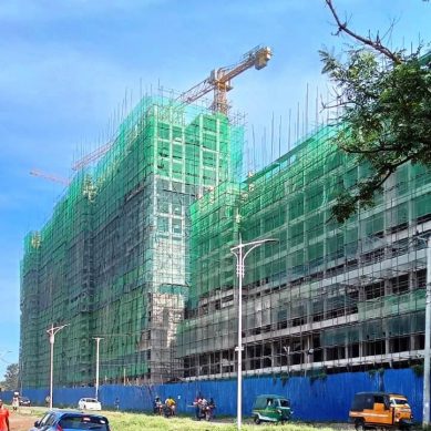
Particularly, the emergence of high-rise buildings and towering mega infrastructure have brought to the fore the need to establish the soundness of the location which the projects are built on.
The World Bank through the National Construction Authority assisted by geophysicists started a project for designing codes for buildings for emerging cities along the rift.
The codes inform several parameters in construction like types and strength of materials, the maximum load and number of floors by calculating the resilience of structures to withstand incidences like earthquakes.
- A Tell / KNA report / By Wagema Mwangi


About author