

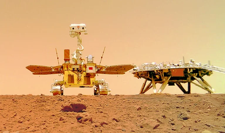
China’s Zhurong rover has peered deep under the surface of Mars, finding evidence of two major floods that probably shaped the region the robot has been exploring since it landed in May 2021.
An analysis published in Nature his week is the first result from Zhurong’s radar imager, which can probe up to 100 metres below the surface. “It is a very interesting paper, and I was particularly impressed by how deep they can see with this radar,” says Svein-Erik Hamran, a planetary scientist at the University of Oslo, who analysed the only previous data from ground-penetrating radar used on the planet, collected by NASA’s Perseverance rover.
The history of Zhurong’s landing site – on Utopia Planitia, vast plains in Mars’s northern hemisphere — has puzzled scientists. Some have theorised that water or ice was once a feature of the landscape. Observations from space have identified sedimentary deposits that suggest the region was once an ancient ocean or submerged by huge floods, and geological features, such as pitted cones, resemble structures formed by water or ice.
In May, researchers analysed infrared images of the landing site taken by China’s Mars orbiter, Tianwen-1, and found hydrated minerals that could have formed when groundwater rose through the rock or ice melted.
But the region could have also been covered in lava, concealing some of these hydrological processes in the subsurface. Eruptions from the volcano Elysium Mons to the east of the landing site, or other volcanic activity, could have covered the region in magma, as has been observed in other parts of the Utopia basin. By studying the radar data, researchers hope to understand what happened, and whether water or ice could still be lurking below the rocks.
“We want to know what is going on beneath the surface,” says study co-author Liu Yang, a planetary scientist at the National Space Science Centre in Beijing.
Zhurong is China’s first rover on the red planet, and it has been exploring the southern part of Utopia Planitia. The rover’s ground-penetrating radar transmits high-frequency radio waves that can penetrate the surface to a depth of between 3 and 10 metres, and low-frequency waves that can reach up to 100 metres underground but offer poorer resolution.
The study authors analysed low-frequency data taken between May 25 and September 6 over more than 1,100 metres of terrain as Zhurong travelled south of its landing site. Radar signals reflect off materials under the surface, revealing the size of their grains and their ability to hold an electric charge. Stronger signals typically indicate larger objects.
The radar did not find any evidence of liquid water down to 80 metres, but it did detect two horizontal layers with interesting patterns. In a layer between 10 and 30 metres deep, the team reports, the reflection signals strengthened with increasing depth.
The researchers say this is probably due to larger boulders resting at the base of the layer, and smaller rocks settling on top. An older, thicker layer between 30 and 80 metres down showed a similar pattern.
The older layer is probably the result of rapid flooding that carried sediments to the region more than three billion years ago, when there was a lot of water activity on Mars, says co-author Chen Ling, a seismologist at the Institute of Geology and Geophysics, Chinese Academy of Sciences, in Beijing.
The upper layer could have been created by another flood some 1.6 billion years ago, when there was lots of glacial activity. Chen says it is unlikely that the upper layer contains intact lava flows, because it has a smaller ability to hold an electric charge than would be expected for intact volcanic rocks. Furthermore, the researchers didn’t see any sudden changes in layering, which would be expected when lava flows meet sedimentary material.
But, Chen says, it is possible that a thin coat of lava once covered the upper layer and it has gradually been broken down into smaller pieces. Radar data alone cannot definitively reveal whether material is sedimentary or volcanic, says Xu Yi, a planetary scientist at Macau University of Science and Technology.
Radar data are good at indicating the layering and geometry of subsurface material, but not so good at pinpointing its composition, including whether the material is ice or rock, says Hamran. Often, researchers rely on other clues, such as rocks peering out from the surface, to build a picture of past events, he says. The authors say they can’t rule out the possibility that the region contains buried saline ice.
More radar results are expected from the mission, including data taken during Zhurong’s continued traverse of Mars, results from the high-frequency radar measurements already made, and Tianwen-1’s orbital radar observations, which penetrate deep into the planet. They could help to clarify details of the terrain. “This is only the first step,” say Ling.
- A Nature report


About author